


.png)
The Ferdinand Gold Project
Project Snapshot
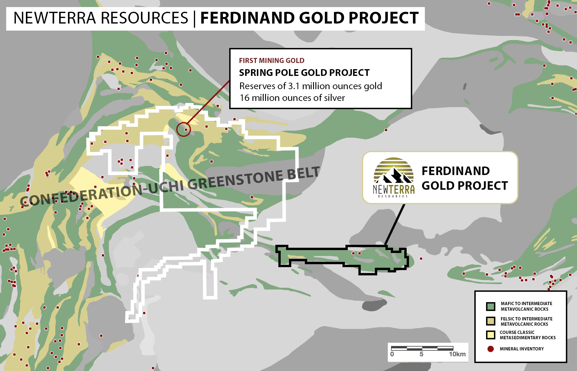
Location: Red Lake Mining District, Northwestern Ontario
Land Package: +15,000 acres
Regional Context: Situated in the eastern extension of the Confederation-Uchi Greenstone Belt, straddling the Fry-Bamaji deformation zone.
Primary Targets: Orogenic gold hosted in folded Iron Formations (Fe-Fm) and sheared metasediments.
Ferdinand Gold
Executive Summary
The Ferdinand Gold Project represents a compelling, early-stage exploration opportunity located approximately 13 kilometers northwest of Slate Falls, Ontario. The property covers a large strategic land position centered on the crustal-scale Fry-Bamaji deformation zone.
Despite its prime location within a major greenstone belt, the property remained significantly under-explored due to previous access issues. In recent years, major logging efforts have added new roads and exposed outcropping creating new mineral exploration opportunity.
Location
The project is located near First Mining’s Springpole Gold project and in the same region as the Kenorland/Auranova South Uchi project.
This portion of the Red Lake Greenstone Belt has recently seen significant staking activity, with companies such as Kenorland, Elemental Royalty, Kinross and First Mining all now holding significant land packages in the area.
Geology & Mineralization
The property is underlain by the Uchi Subprovince, characterized by a belt of metavolcanic and metasedimentary rocks interlaced with granitoid batholiths.
Key Geological Features-
Iron Formation Targets: The priority target on the property is a strong, linear magnetic anomaly, identified in the field as a banded Iron Formation (Fe-Fm). This unit extends in a northwest-southeast direction and varies from 1 to 3 meters in width.
Structural Complexity: The Fe-Fm is boudinaged and bounded by shear zones, including biotite-garnet-amphibole schist and phyllite schist.
Lithology: Outcrops observed include interlayered mafic metavolcanic flows (pillows), debris flows, and chemical metasediments intruded by granitoid stocks.
Historic Exploration
The area of the Property has been intermittently explored since the 1890s. The earliest work was reported on the Silver King showings in the eastern part of the Property, which described minor underground gold production in the 1939 to 1941 period from a gold-quartz vein associated with molybdenite in sheared granodiorites. Intermittent subsequent exploration of the Silver King area occurred between 1964 and 1978 with unsuccessful underground and diamond drilling.
More comprehensive exploration covering the entire Iron Horse Property was initiated by Fairfield Minerals in 1986, and discovered high silver grades in prospecting samples ranging up to 68 g/t Ag, but low gold and a lack of associated base metals. Subsequent drilling program in a joint venture with Placer Dome using short percussion drill holes targeting gold in soil geochemical anomalies did, however, reveal numerous significant intersections of gold mineralization. The final work by Fairfield Minerals was in 1994 when 4 diamond drill holes were completed to examine percussion drilled gold anomalies.
King Resource Ltd. (1963-1965)
Molybdenite is reported to have been discovered by R.S. Taylor and J.E. Nott in 1963, in waste dumps in the area of the Alma Mater and the Silver King workings (Figure 4). The discoverers staked the area, and the property was subsequently referred to as the Silver King Group (Robinson, 1965).
Trenching and test-pitting, which was carried out in 1964 in the vicinity of the historical workings, yielded no records except for the observation that the mineralization comprised threads and stringers of molybdenite with sparse coarse 15 pyrite and rare chalcopyrite, associated with a white, siliceous, fine-grained, bleached, altered and unevenly textured rock. In thin section, the rock was seen to comprise mainly quartz with much altered plagioclase, carbonate, and phlogopite mica with lesser apatite and cordierite.
The presence of quartz veins with molybdenite and galena was noted. by Robinson (1965) who also mapped the Alma Mater and Silver King underground workings. The underground observations at Alam Mater from Robinson (1965) were that a number of quartz veins with pyrite and intermittent galena, and possibly molybdenite, characterized the mineralization. The lower tunnel (Fig. 3) exposed an east-northeast striking and south dipping shear zone at the contact between feldspar porphyry and greenstone. Feldspar porphyry was observed at the entrance to the main tunnels transitioning into granodiorite. The Silver King adits generally are mineralized by quartz veins with pyrite and minor very fine-grained grey sulphides, including galena or molybdenite hosted in shear zones.
Brenmac Mines Ltd. 1966
The earliest reported work on the eastern side of the Iron Horse Property, around the showing of the same name, came in 1966 from Brenmac Mines Ltd. who completed Induced Polarization and resistivity surveys, geological mapping, soil sampling, trenching and test pitting, and eleven short percussion holes totaling 250 meters drilled with the objective of locating porphyry type mineralization similar to the recently discovered Brenda ore body (Hallof and Bell, 1966). The IP survey revealed relatively weak irregular patterns of chargeability and the other results were not available.
Anuk River Mines Ltd. 1967
A large area north of Greata Creek was restaked in 1967 by Anuk River Mines Ltd. who carried out geochemical soil surveys, and 305 meters of drilling in three holes principally for gold. Mineralization in the drill core was sparse black sphalerite with minor amounts of chalcopyrite and pyrite in sheared quartz diorite, or granodiorite, with few or no quartz veins but containing epidote, calcite and chlorite seams and veinlets (Lazenby and Read, 1967 AR 01110).
Brenda Mines Ltd. 1978
In 1978, Brenda Mines Ltd. restaked an area of the Property centered around the confluence of Bolingbroke Creek with Greata Creek to cover the areas around the Alma Mater and Silver King prospects. Two diamond drill holes were reported by Bankes (1980, AR 07872) divided as 2 holes totaling 200 meters at Alma Mater and 2 with 79 meters at Silver King. The target was the extent of the sericitized diorite-granodiorite and the associated molybdenite- galena mineralization. At Alma Mater GR-3-79 graded 0.003% Mo and 0.004% Pb over 135 meters with some continuity to drill hole GR-4-79, which averaged 0.005% Mo and 0.002% Pb. At Silver King, the extent of the sheared, sericitized granitoids was found to be minimal and the mineralization weak.
Esso Minerals Canada Ltd. 1980
Esso Minerals completed two geophysical surveys over parts of the Property in 1979 and 1980 (Stewart, 1980; AR08143). In 1980 a ground magnetometer survey was completed on 24 line km in the eastern part of the present Property and in 1981 a helicopter-borne magnetometer and EM survey over 810 line kilometers of a grid extending NW from the shore of Okanagan Lake towards Peachland Lake and north to Trepannier Creek. The ground survey highlighted areas around some of the skarns in the Iron Horse showing area, though it was not clear if they were responding to magnetite in the intrusive diorites or the skarns themselves. The airborne EM survey showed weak anomalies related to overburden.
More Information
Interested in investing in Newterra Resources? Visit our investor page or get in contact.